2D hydraulic modelling short course
“Flood risk in urban areas”
DATES 9-11 July 2018
OBJECTIVES
The training course is for professionals, researchers and students interested in the use of hydraulic
models for hydrogeological risk. The course introduces and deepens the theoretical and applicative aspects related to the use of the two-dimensional hydraulic model FLO-2D (http://www.flo-2d.com/), the state of the art in 2D hydraulic modelling for floo risk and among the most used in the world for flood risk mapping and for the engineering design of flood mitigation works. 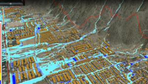 FLO-2D is approved by FEMA (USA) to support hydrologic and hydraulic modeling and simulation of flood wave propagation in urban/natural environments, to simulate debris flow, floods in coastal areas due to storms and tsunamis. The 3 days course will guide beginners and more experienced users from the early stages of learning to the use of the most advanced FLO-2D components. The first two days, all participants will be guided through a learning path to use all
the components and functionalities of the software, while the third day is dedicated to the development of projects of interest and to the specifc topic of the short course “Flood risk in urban areas”.
INSTRUCTORS
Fernando Nardi
Jim O’Brien
Karen O’Brien
Noemi Gonzalez-Ramirez
LANGUAGE
The course will be taught in English, nonetheless assistance in Italian will be provided by the developers for those who need it
LOCATION
IDRAN Ingegneria e Tecnologia Srl, Via Gregorio Settimo, 186, 00165 Roma (RM)
ACCOMMODATION INFO
The location of the course is well surrounded by numerous hotels, B&Bs and apartments. Look at the map.
NUMBER OF AVAILABLE PLACES (15)
The course has a maximum capacity of 15 participants. Once the limit is reached any further request to join the course will be refused.
FEES
The registration fee cost is 595,00 € + VAT 22%. Discounts are offer to young professionals 495,00 € + VAT and students up to Master and PhD level (maximum age 32 years old) 300,00€ + VAT 22%.
PAYMENT
Money transfer to IDRAN Srl. IBAN: IT81M0306905064100000000449
REGISTRATION FORM
Please fill and submit the online registration form to participate in the course.
AGENDA AND DETAILS
The agenda and details of the three-day course are listed below. Primary ‘hands-on’ computer sessions are highlighted in blue.
Monday, July 9, 2018
Getting Started, Hydrology and Channel Flood Routing
8:00 – 8:15 Check-in, introductions and review agenda.
8:15 – 9:00 Overview of the FLO-2D Pro modeling system. New features and enhancements. Grid Developer System GDS – getting started.
9:00 – 10:00 Lesson 1: Using the GDS to import and edit terrain elevation data, filter elevation point data, establish a grid system, work with aerial images, setup hydrographs and run the FLO-2D model. Floodplain attributes; edit model components and layer attributes using shape files.
10:00 – 10:15 Break
10:15 – 10:30 Discussion of routing algorithms and stability criteria.
10:30 – 11:15 Hydrology, volume conservation, flood hydrology, and unconfined flooding; Rainfall and inflow hydrograph. Infiltration and simulation of realtime spatially variable rainfall. Building runoff and downspout simulation.
11:15 – 12:00 Lesson 2: Enter/edit rainfall and infiltration data. Run a rainfall – runoff model.
12:00 – 1:00 Lunch
1:00 – 1:30 Review data files and introduction to urban modeling.
1:30 – 2:30 Channel flood routing overview. Channel/floodplain flow exchange. Overview of GDS drainage channel tools. Introduction to Lessons 3 and 5.
2:30 – 2:45 Break
2:45 – 4:15 Lessons 3: Using GDS to create a simple rectangular channel; Interpolating the channel cross sections and slope and editing the bank elements in PROFILES and GDS. Working with channel cross sections. Working with natural channels.
4:15 – 5:30 QGIS Plug-in Tool. Overview and Getting Started
Tuesday, July 10, 2018
Hydraulic Structures, Levees
8:00 – 9:00 Using hydraulic structures: weirs, bridges and culverts for rivers and floodplains. Generalized culvert equations for inlet and outlet control.
9:00 – 9:45 Lesson 4: Hydraulic Structures.
9:45 – 10:00 Break
10:00 – 10:45 Storm drain modeling – surface water/storm drain exchange.
10:45 – 11:15 Storm drain details, data input and results.
11:15 –12:00 Lesson 5: Create a simplified storm drain system.
12:00 – 1:00 Lunch
1:00 – 2:00 Urban Features: buildings, walls.
2:00 – 3:00 Lesson 6: Urban Modeling.
3:00 – 3:15 Break
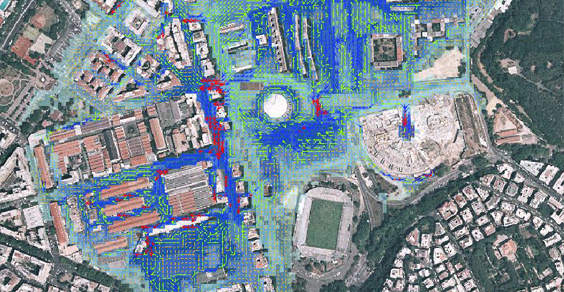
3:15 – 4:00 Mapping: Create high resolution flood inundation maps.
4:00 – 5:00 Lesson 7: Display flood depths, velocities, damage assessment and hazard maps.
Wednesday, July 11, 2018
Troubleshooting, Project Optimization and Work on a Project
8:00 – 9:00 Limiting Froude Number, Numerical Stability and n-value adjustment
9:00 – 9:45 Low Impact Development. Examples of LID techniques in large scale models.
9:45 – 10:00 Break
10:00 – 11:00 Troubleshooting, tools and methods for finding data errors.
11:00 – 12:00 Lesson 8: Troubleshoot a project.
12:00 – 1:00 Lunch
1:00 – 2:00 Project model optimization and review.
2:00 – 3:00 Lesson 9: Create a project start to finish.
3:00 – 3:15 Break
3:15 – 5:00 Lesson 9 (cont.): Create a detailed urban project from start to finish. Project includes grid, elevation, buildings, roughness, drainage channels, hydraulic structures, walls, streets and storm drain.